
(Un)settling the Scene
Alongside melting glaciers, marine oil spills and sinking islands, large-scale monocrop plantations have become emblems of the so-called “Anthropocene.” This term, which is derived from anthropo meaning human and cene meaning new in Greek, has gained traction in recent years to describe the current epoch, in which humans have become the single greatest geological influence on the planet. In Indonesia, the world’s top palm oil producer, the plantation boom has contributed to a range of adverse social and environmental effects, including rampant deforestation and the dispossession of forest-dependent indigenous peoples [1].
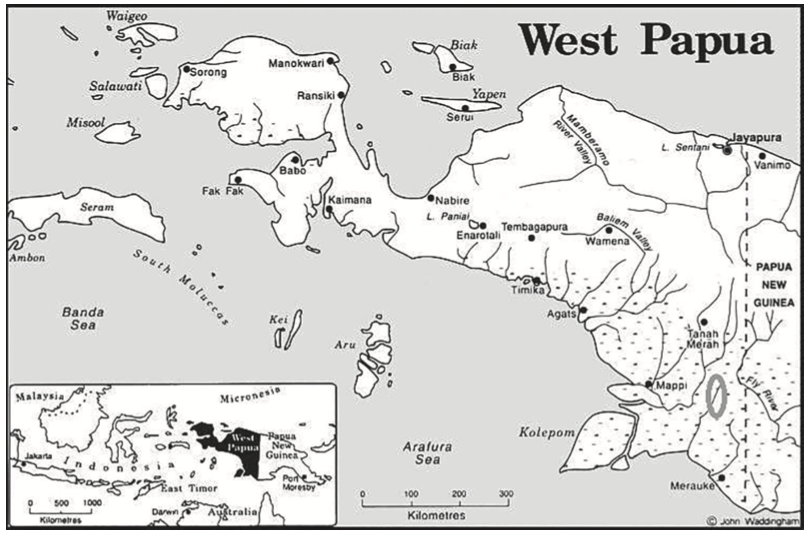
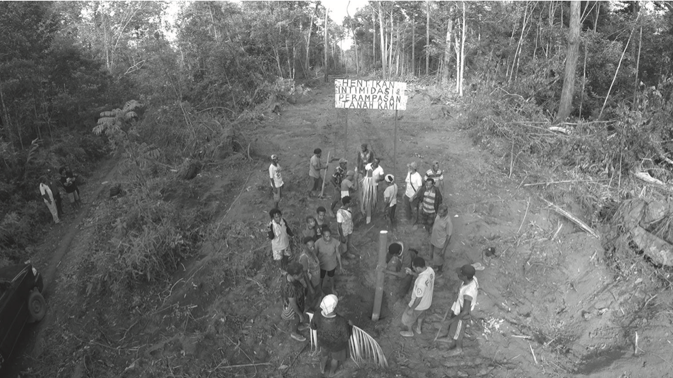
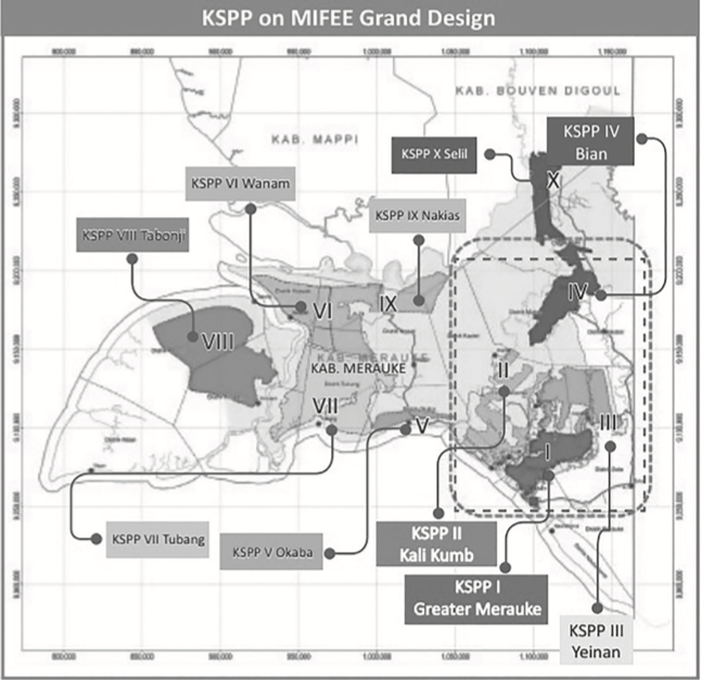
With land growing scarce in Sumatra and Borneo, the oil palm frontier is rapidly moving eastward into West Papua, where rainforest and savannah are being razed at an unprecedented rate [2]. In particular, oil palm expansion in the Papuan regency of Merauke, a remote region of swamplands and savannah on the border with Papua New Guinea, has been the subject of growing campaigns led by nongovernmental organizations (NGOs), including advocacy at the level of the United Nations [3]. Largely implemented without the free, prior and informed consent of the indigenous Marind-Anim people (hereafter the Marind), oil palm expansion has been facilitated by widespread collusion among corporate, state and military interests.
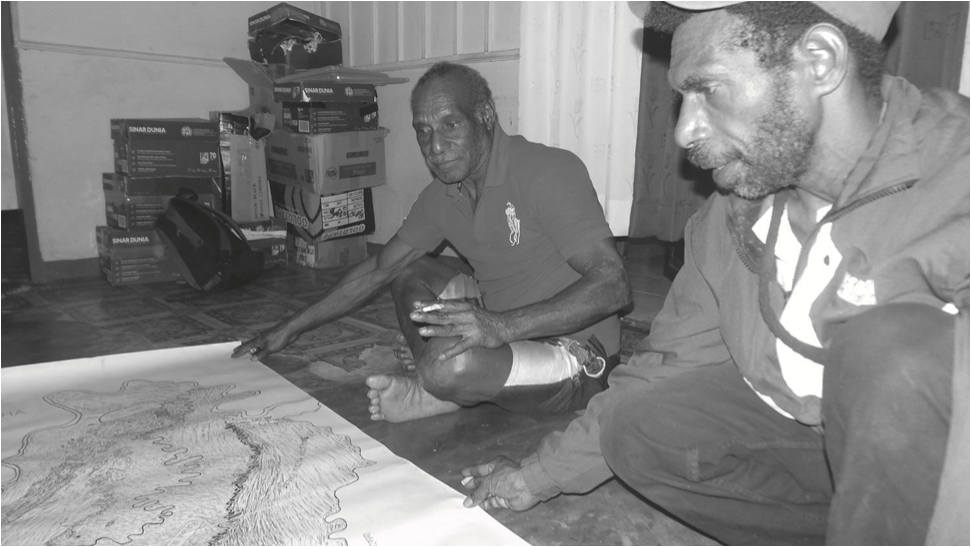
Along the banks of the Bian River in northern Merauke, I carried out fieldwork among several Marind communities whose lands and settlements are encircled by large-scale oil palm plantations established in the last decade. Participatory mapping with local communities is one of the key tools being used in the area to protect remaining forest areas in indigenous territories from oil palm incursion. This article explores maps as objects and mapping as practice, both of which are part ethnographic method, part advocacy tool.
As ethnographic tools, maps and mapping can provide important insight about how our research participants conceptualize place within their particular cultural value systems and cosmologies. Among the Marind, for example, mapmaking reveals that place is a dynamic entity shaped by the lives and doings of multiple actors, both human and nonhuman. In producing their own maps, the Marind convey this sense of place as a multispecies endeavor by emphasizing the role of different organisms in shaping it and giving it meaning. In this respect, places and the maps that represent them are lively entities, characterized by constant movement and transformation. The consequence of this is that Marind maps themselves keep morphing and never sit still, in the image of the multispecies world itself.

As an advocacy tool, community mapping like that undertaken by the Marind is an important means of conveying to states and corporations the various cultural values that people associate with land. In the eyes of more powerful actors, maps can therefore serve as forms of “proof” of the rights to land and resources of indigenous peoples subjected to development projects that undermine these rights.
A growing concern, or perhaps expectation, among anthropologists regarding the knowledge they generate is that it should engage with contemporary issues and provide insights into the cultural worldviews that shape social relations, including conflictual ones in contexts of power imbalances. The liveliness of Marind maps — the fact that they never sit still and are always “works in progress” — reflects fundamental cultural understandings of place as movement. However, the fact that maps are always unfinished may also undermine their effectiveness and value in contexts of advocacy directed toward the government and corporate sector. The Marind themselves are very much aware of the tensions inherent in producing maps that are both culturally accurate and politically strategic.
The Marind have come to see the government and oil palm companies as the destroyers of the multispecies worlds displayed on Marind maps and of the movement seen on such maps. When I spoke to them, they blamed this on rampant deforestation and oil palm expansion. Not surprisingly then, the Marind critiqued the government and company maps as static, lifeless representations of place that fail to account for multispecies endeavors that give place meaning. This article suggests that the insistence of the Marind in keeping maps lively and constantly changing is not solely an expression of their cosmology. It also constitutes a veiled, if sometimes counterproductive, strategy of resistance to state and corporate forces that, through actions and maps, erode the meaning of place as multispecies movement and generative liveliness.
Of Spirits and Species
Traditionally a nomadic hunter-gatherer community, and still largely reliant on the forest for their subsistence, the Marind self-identify on the basis of membership to one of several clans. Members of each clan are related by kinship, myth and genesis in particular animals, plants and natural features of the for- est. These animals and plants are described as amai, meaning “grandparent.” The Marind believe amai have consciousness and agency, as people do, and that they have their own particular affects, capacities and volition. Humans, amai and ancestral spirits (or dema) all participate in different ways in shaping, through their movements and actions, the dynamic living space that is the forest.
“One is never alone in the forest,” says Paskalis, an elder of Khalaoyam village. Instead, one encounters in the forest a lively, more-than-human realm, teeming with multispecies worlds in the making. There are the ceaseless labors of busy red ants underfoot and the slow and imperceptible growth of centennial aloe wood trees. The seasonal migration of egrets, the trajectories of wild boar packs in search of food, the transplanting of sago suckers along river banks and groves, the journeys of warmongering ancestors and the travels of deceased and living relatives are but some examples of place-making movements that endow the forest with its dynamic and multispecies relief. “Place,” in the words of Marcus, an elder from Selam village, “is a journey,” in which the wayfarings of plants, people, animals and spirits partake. Place comes into meaningful existence as various lifelines form intricate and time-transcending meshworks that are at once historical and continually emergent.
Pressure Points
The controversial incorporation of West Papua into the Indonesian state in 1969 has been accompanied by the emergence of a network of “pressure points” across this living and moving landscape. Military garrisons, towns, roads, police headquarters and, more recently, the carving out of privatized oil palm concessions all stultify human and nonhuman movements. These forces also destroy the lives and pathways of human and nonhuman beings while subjecting them to the omnipresent surveillance of a powerful state, military and business nexus. The past, embodied in the rapidly vanishing forest, is eradicated, rendering the present precarious and the future uncertain, a reality that many Marind convey through the expression “time has come to a stop.”
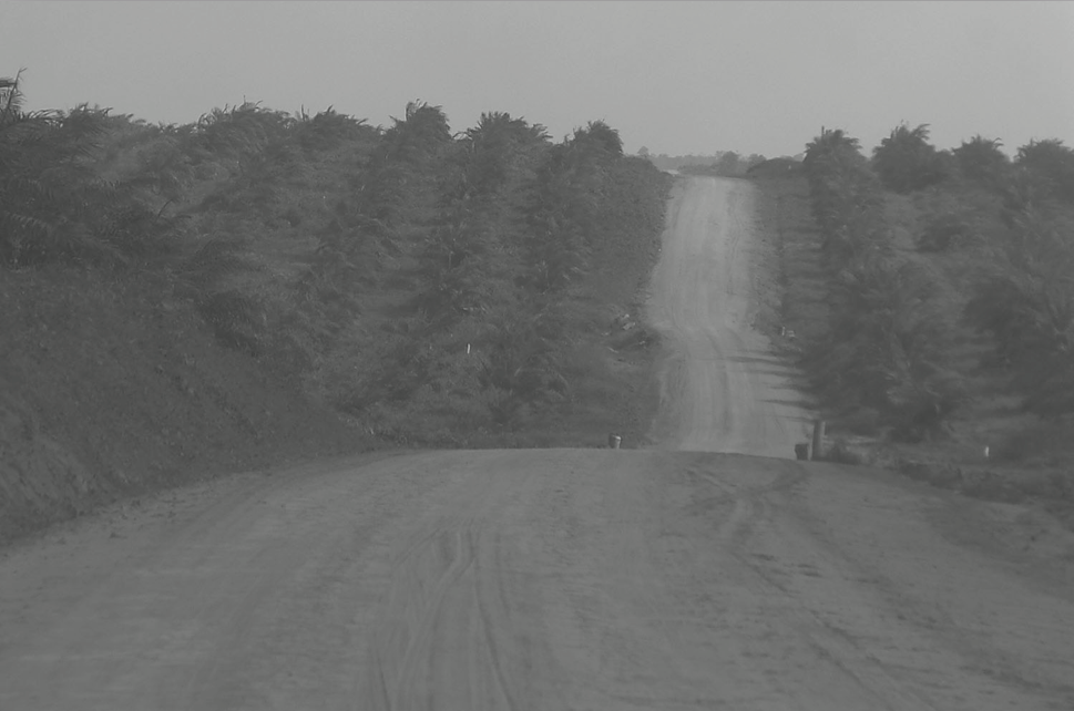
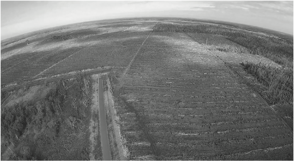
In particular, the advent of oil palm plantations in the last decade is the subject of great concern among the Marind. Uncannily similar to military garrisons and training grounds, the plantations extend over vast swathes of land and are out of bounds to nonpersonnel. Their entrances and exits are strictly guarded and trespass is heavily sanctioned. Rows of equidistant, uniform oil palm trees crisscross the plantations, like a regiment of obedient, disciplined soldiers, identical to each other in appearance and size. Always located on elevated land, police, military and company headquarter bases survey the concession from afar and above, the visibility of movement and presence substantially aided by the general flatness of the oil palm landscape.
Oil palm, unlike the plants and animals of the forest, is considered by many Marind a selfish and solitary being. It is “without friends and family.” “Oil palm,” says Selly, a middle-aged woman from Selam village, “does not like the company of others.” Indeed, few endemic species are able to survive in the low canopies, sparse undergrowth and low-stability microclimates of monocrop plantations. The conversion of natural forests to such plantations has also increased habitat fragmentation and biodiversity loss, the monoculture model resulting in barriers impervious to species migration [4]. The life-giving movements of animals and plants, ancestors and spirits, humans and nonhumans, are increasingly impeded by the incursion of oil palm and the solitary, oppressive places that it occupies.
There Are No Straight Lines in Nature
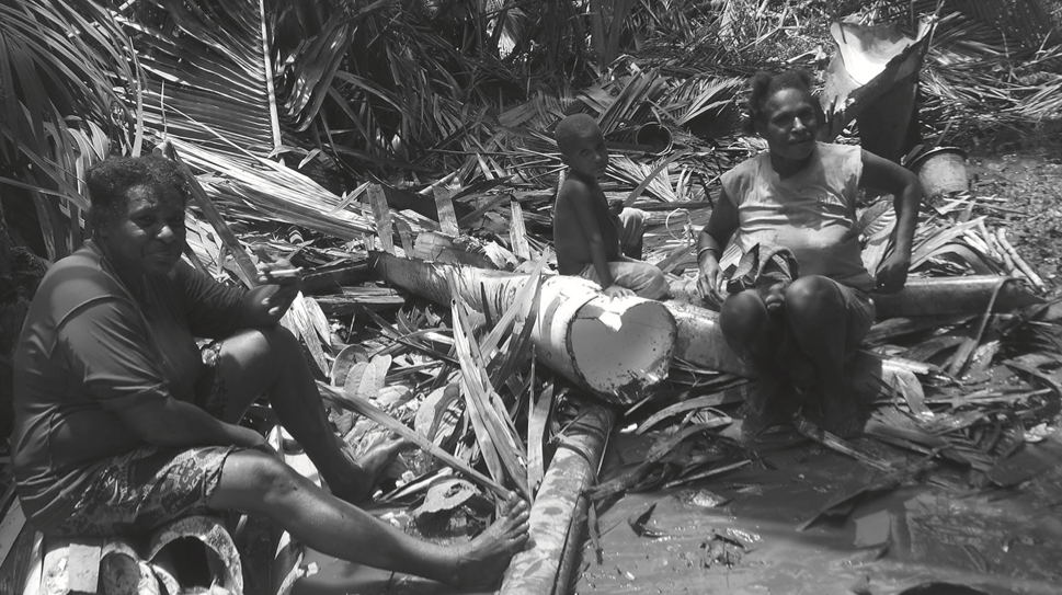
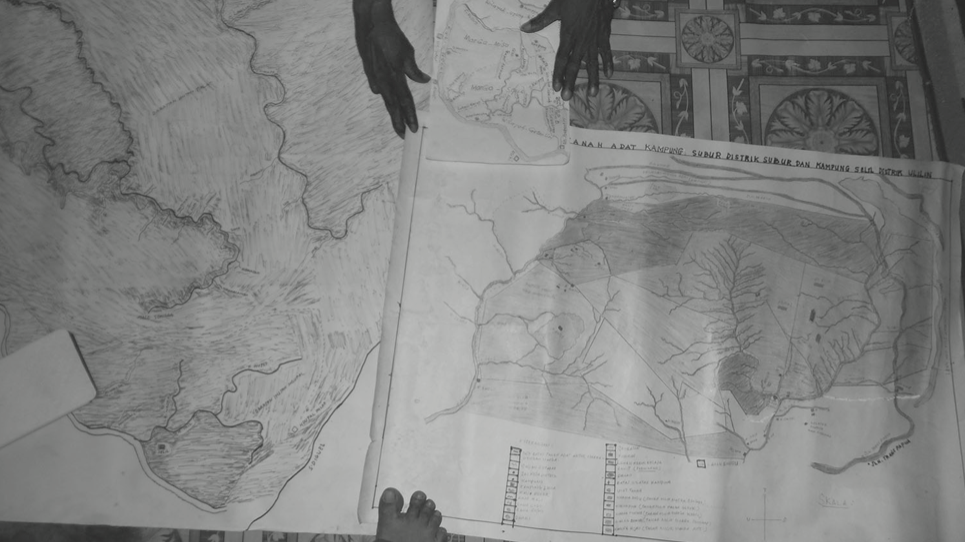
Sitting at the foot of the mango tree by the old church of Selam, a group of Marind community members and I had gathered for a moment’s rest after an unsuccessful fishing trip on the western banks of the Upper Bian River. Stretching our limbs, we munched on grilled sago and coconut, discussing the recent flow of greasy effluents from the palm oil mill into the river that had, as the Marind say, “made the fish drunk.” Mid–betel chewing, we were interrupted by Paulinus, a bright and energetic young man, who came running, a bulky cardboard box under his right arm, calling, “Hey! I found another map! Check it out!” He carefully pulled out a laminated A3 map titled “Investment Planning Map 2010 – 2030,” produced by the Merauke Regency Division of the National Spatial Planning Agency. Taking photographs of the document with my smartphone, I listened attentively to the group’s cartographic critique.
Administrative boundaries. Oil palm concession boundaries. Timber concession boundaries. National conservation zones. Mining concession boundaries. A doubtful look on her face, Rosalina, a middle-aged woman from Khalaoyam, followed with her callused finger the color-coded straight lines carving up the landscape into a series of overlapping geometric shapes. Shaking her head, she concluded: “There are no straight lines in nature.” The group nodded in assent, and Okto, Rosalina’s younger brother, added:
Nothing moves in straight lines like this. Look at the seasonal flight of the birds, the journeys of the cassowary and the wallaby, the monsoonal movements of the fish and prawns. Look too at the way the sago reproduces following the curve of the Bian, the way our ancestors and we still today, follow this movement to feed and protect ourselves. Look now at the flow of the Bian itself — swaying right, then left, then right again, it has direction but no rigidity. Nothing grows in straight lines, apart from oil palm.
At this point, Marcus, a rather introverted and shy young man who had been looking at the map at a slight distance from the rest of the group, turned to me and asked: “Can you make this map alive?” I was confused and looked to the others for help. Their rephrasings of the question (“Can you give this map some life? Can you bring it to life?”) were no clearer to me. Eventually, Marcus explained:
You see, it’s like this. This map, I think, is what the government and companies see. Just land and borders and oil palm. But there is something dead about this map. I don’t know if “dead” is the right word, because even in death there is some kind of movement, but what I mean is that there is no sign of life. There are no people, or birds, or animals, or plants to be seen. Just patches of color that don’t mean much at all. Everything just sort of stands still on this map. When I look at it, I don’t hear anything that tells me where I am. I don’t see who surrounds me. Do you know what I mean, Miss?

I tried to explain to Marcus that not everything could be included in a map for reasons of scale and detail. But Marcus insisted that without that kind of “life,” the map was pretty much “useless.” Borrowing my pen, he started to show me what it meant to add some life to the map. Here, he traced the paths of the spirits of his clan across forest and marshland. Further to the left, he circled the sites of interethnic peacemaking rituals, warfare and congregations. Scattered across the map, he pinpointed the funerary sites of great warriors of the past. In long, broad strokes, he drew the movements of migratory birds and their places of rest, feeding and mating. Then there were the aquatic journeys of native fish, followed closely by those of their predators. His excitement growing, Marcus traced in detail the swooping trajectories of the bird of paradise, the amphibian proliferation of sago suckers along the Bian riverbanks. Then he added the flight of the wallaby during slash-and-burn forest clearing, followed by its inquisitive return in the wet season to feed on juicy new shoots in the forest regrowth.
Other group members began to join in, putting movement and multispecies lives back into the map with arrows, arcs and scribbles. Each addition to the map was accompanied by stories of the species whose lives and doings gave place its meaning. Concession and administrative boundaries disappeared under a dense meshwork of intertwined, interconnected and multitemporal existences. This process unflattened time and space by reinscribing them with movement.
In this and many other instances, Marind saw government and company maps as both limited and limiting. They believed that such maps were disconnecting places and persons, deanimating symbiotic life flows and circuits and dissolving the dynamism of multispecies becomings into hard and fast boundaries and zones. The liveliness of place was diluted and dissected in government maps into static, rigid taxonomies of perceived economic value and expected productivity. My interlocutors talked of maps as instruments of control and deception by a state whose painful and ongoing legacy of violence, human rights abuses and intimidation continues now in the form of imposed oil palm expansion.
But they also noted the inconsistencies across different government maps in terms of scale, administrative and concession boundaries, forest classifications and concession types. For example, the northern village of Kharam in some maps finds itself inside Boven Digoel district, in others in Merauke district. District boundaries seem to strangely move to accommodate plantation concession delimitations. A timber concession on paper turns into an oil palm concession on the ground. Map scales across different sources somehow never seem to match or fit when overlaid. Concession areas contract and expand, changing names, changing crop. Certain planned developments never end up materializing, while others are activated without any prior notice. Areas supposedly protected from deforestation shrink suspiciously in consecutive annual maps.
Perhaps, in the words of Yakobus, “the government itself is confused.” Government maps are as unfinished as the spaces they seek to control through visual representation. For certain, the “signature of the state,” in the words of anthropologist Veena Das, on paper and place is at once hegemonic and oppressive on the Marind [5]. But it is also ambiguous and volatile. In this ambiguity the Marind see the possibility of their own intervention to curb the radical landscape transformations taking place with the advent of oil palm. Making maps of their own constitutes one such strategy.
“Follow the Song of the Khaw”
After a breakfast of baked sago and boiled taro, a group of Khalaoyam elders and I headed out eastward to map the customary territory of the Mahuze clan. This triangular area extends from the coconut grove on the banks of the Upper Bian further east to the “milk tree” (Astonia scholaris) promontory and then south to the Arvak spring. Armed with two GPS devices, we started walking. Mahuze elder Yakobus lead the group, humming tunes of his childhood and regularly calling out our individual names, a Marind habit to ensure that peoples’ souls do not get lost or captured by malignant spirits dwelling in the forest and swamps.
I followed Yakobus, keeping my eyes on the ground to avoid tripping over thick tangles of buttress roots and picking off insistent leeches from my arms and legs as they crawled up from the moist hummus or dropped down conveniently from overhead foliage. Yakobus suddenly stopped in his tread, causing me to nearly run head first into the newly sharpened machete dangling off his back. Looking up at the dense canopy, interspersed with green-hued shards of light and swaying gently in the morning breeze, he stood in silence. Suddenly, he pointed up and looked at me, saying “There it is. That’s our first point. You can map that.”
I couldn’t tell what Yakobus was pointing to, or what needed to be mapped, or under what caption in the GPS device, so I asked him to explain. “Can’t you hear, Miss? Can’t you hear the whistle of the khaw up there? [6] That’s one of our dema, telling us it knows we are here, and it sings for us to continue our journey. This is an important place because it is a place of encounter with the khaw dema, so it must be mapped. Follow the song of the khaw.” Luckily, a savvy techie friend of mine had set up software in my GPS unit to record sound, so I promptly recorded the shy whistle in the wind, the black and yellow plumage of the small bird invisible to my eyes. I wondered how to name this coordinate that existed to me as a mere sound clip but to my informants was a place-making sensory experience. Beep. Whistle. Khaw.
Yakobus then proceeded to tell me the story of the khaw, how it sprung from the wet soils of the Upper Bian, feet first and head last, hence the dark blotches of its crest, eternal markings of fertile riverine soil. How it drank from the Bian River and from there received the power of flight, which allowed it to circle the moon and the sun, grabbing sunlight under its wings, forever tainted bright yellow from its rays. The story recounts how the khaw’s whistle guided the Mahuzes’ ancestors as they traveled across the lands in search of food, falling upon sago at the banks of the river where the bird had led them. It explains how its whistle enchanted the children and brought the fish to surface to feed the Mahuze people. And finally it is a story about how the khaw sings at dawn to mark the rise of the sun, today still guiding the Mahuze’s members across the forest, giving direction to their steps, protecting them from witchcraft and harm.
Yakobus went silent, then began, slowly, then with faster cadence, in a low, hoarse voice, to sing the song of the khaw. The other group members lowered their heads in respect, some sniffling, teary-eyed, remembering the past, their kin, their childhoods, their mothers. The GPS unit continued to record the sound of place and movement through the stories and songs of human and bird. I wondered how a single red dot on the map would convey the temporal, affective and ontological depth and directionality of this symphony of a timeplace.
Following the movement of the khaw, we roamed the forest, as my friends explained the fruit trees from which the bird fed, the particular riverbanks it would drink from, the sago groves it would nest in, the place it came into existence, and the place it goes to sing its last song. Each of these places was in turn mapped into the GPS unit forming a sort of khaw lifemap. In turn, each coordinate was connected by my interlocutors to those of other beings, happenings, times and songs that had emerged symbiotically in these and nearby sites. Each node came to connect rich and dynamic multispecies lifeworlds and movements across time and space.

The names of ancestors, the peacemaking rituals, the death of a wise woman from witchcraft, the trees from which Marind canoes and bows are made, the shrubs whose white-pink inner bark is used as medicine and plasters, the sago grove where the wild boar comes in search of food inside hollowed-out boles, the river bend where the dog spirit of the Mahuze clan took a nap only to turn into a stone mound visible to this day, the resting place of the snake spirit and the shallow sleeping holes of the Tilapia fish submerged in water in the wet season—these, and countless more, shared biographies, we recorded and noted, accompanied by photographs and sound clips, following the song of the khaw.
The landscapes my friends wanted to map were in no way limited to those that related to their history and past, or to ancestral dema beings. The coordinates we “mapped” as sound (for most were not “visible” in the literal sense of the term) included those of birds, the wind and sago-pounding, or what Feld, in his work among the Kaluli of Papua New Guinea, has called the “poetic cartographies of rainforest trails” [7]. But they also included sounds that coexist awkwardly, often jarringly, with these more “traditional” acoustics: roaring bulldozers, distant chainsaws, passing trucks, the Muslim call to prayer of nearby settler village mosques, the solemn intermittent bell-ringing of the local church, the xylophonic lunch-break Für Elise chime of the state primary school and the triumphant if somewhat crackly “Indonesia Raya” national anthem trickling from military garrison megaphones in between the shrill crescendos of stubborn static. And, inside the nearby oil palm plantation, perhaps the most deafening sound of all.
Yakobus: Listen carefully, child. Tell me now, what do you hear?
Author (hesitant): I’m afraid I hear nothing, Elder.
Yakobus: Exactly. Record it.
The Maps That Won’t Sit Still
The Marind critique government maps for being static and lifeless, often using the visual terms abu-abu (unclear, literally gray) and datar (flat) to describe them. By contrast, the value and validity of maps produced by the communities themselves arise from their personal and personalized production as collective multisensorial endeavors across multispecies topographies of time, place and praxis. The maps produced by the Marind, just like the beings, both human and non- human, who inhabit and enliven the forest, never sit still. Slippery organisms, they acquire liveliness from the movement they convey and conjure — kinesthetic, visual, auditory. Furthermore, the temporal morphing of social ties as they unfold in the everyday make community maps constant works in progress, in the image of relationships made and unmade over time.

Map scales and legends, for example, are defined less in terms of topography than in terms of closeness or distance of kinship, interspecies encounters and historical events. Villages closely connected through family links, histories of reciprocity and exchange are mapped closer than GPS points indicate. Conversely, animus relations, in particular with those groups that had ceded land to companies in the name of other groups, are represented by greater geographical distances. The seasonal migration of birds and beasts requires new lines to be added or shifted, as does the emergence or destruction of sago groves and bamboo clusters. Living maps transform as do the living worlds they seek to represent.
But maps that do not sit still can be difficult to use. Often, to the great frustration of facilitating NGOs and the Church, and months after maps had been produced, some community members would insist that GPS points taken were “no longer accurate.” Maps had to be revised, distances changed, scales increased or decreased, river bends and other natural customary land boundaries redrawn or shifted, sites and locations added or removed. The mapping expeditions I participated in lasted for months on end, yet maps kept transmogrifying. We ran out of pens to color code ever-multiplying legends. As social ties — both human and interspecies — converge and diverge, flourish and fritter, space and distance expand and compress in accordion-like movements to the flux of morally imbued multispecies relationships.
There are no straight lines in nature.
Cartographic Conundrums
Sitting beside me in the front yard of his home, young Oktavianus from Kharam village looked at me as I overlaid different maps on a specialized mapping program on my laptop. One was a missionary map from the 1940s. Another was produced by the Indonesian Ministry of Forestry. Yet another was mapped by the Gebze clan members of Garok village, and another had recently been published by a nearby oil palm concession. Puffing away at a thickly rolled clove-scented cigarette, Oktavianus corrected the spelling of one of the Bian River estuaries on the Kharam map. Then he spoke. “Things are no longer moving. The spirits are angry with us. The plants and animals are starving from too much oil palm. Time has come to a stop. Who knows, maybe one day, the Bian River too, will start to flow upstream? Miss — can your computer draw a river flowing upstream? How do you map time? How do you map life?”

The map can be understood as a form of representation as much as imagination and aspiration. The Marind’s cartographic critique and praxis reveal how they conceptualize and challenge the ways in which the state and oil palm corporations perceive and affect their lifeworlds. Governments and oil palm corporations, in their visual representations and physical reconfigurations of space, disrupt existing multispecies relationships by thwarting the dynamism through which places and persons come to exist meaningfully. By contrast, the living maps that Marind are producing embody the very dynamism that gives place meaning.
The fact that Marind maps seem to never stop moving is in one sense a strategy of resistance to the stasis, destruction and control imposed by the state and oil palm corporations. At the same time, however, the reluctance of the Marind to simplify and render static the textured multispecies world of the forest in the form of fixed maps constitutes a major hindrance to their efforts to secure their lands from the oil palm incursion.
For example, none of the maps that I helped my friends produce have been finalized, and likely never will be. As such, few have been actively used as forms of evidence in negotiations with corporations and the government. Constrained by legal requirements for land exploitation within particular time frames, companies have gone ahead with clearing and planting of oil palm because community maps were not shared early enough. On several occasions, the constantly shifting boundaries of different communities’ territories have resulted in compensation payments to the wrong landowners, in turn fostering intracommunity resentment and horizontal conflicts. In other cases, companies have avoided paying any compensation for lands acquired because the maps did not clarify who those lands belonged to. The iterative and lengthy processes of making maps are also problematic for supporting local NGOs, whose capacity and resources are often limited.
As a staunch proponent of applied anthropology, I was keen to make a tangible difference to the Marind’s growing precarity by facilitating community mapping. However, I struggled to find a balance between accommodating their moving worlds and helping them produce something that would be recognized as legitimate in the eyes of a predatory audience of government and corporate actors with little time to heed stories, songs and sentiment. Far more than a technological exercise of representing simply “what’s there,” mapping dynamic lifeworlds also proved deeply constraining of peoples’ attempts to halt, or at least slow down, the ongoing destruction of these worlds.
However, Marind mapping, as a grassroots-driven technology of territoriality [8], also derives its value from enhancing the visibility of disaffected local communities and their customary lands in the gaze of state and corporations. Albeit fraught with complexities, the villages of the Upper Bian River continue to work together to produce maps as important counter-evidence to the transformations imposed by these powerful actors. In mapping lies the possibility of community empowerment and participation in the representation of space. This is all the more significant in the politically volatile region of West Papua, where indigenous peoples’ self-determination continues to be denied, their freedoms curbed and their cultural rights infringed.
Notes
1. J. Bhattacharya and O. Pye (eds.), The Palm Oil Controversy in Southeast Asia: A Transnational Perspective (Singapore: ISEAS Publishing, 2012).
2. P. Jacobson. “West Papua ‘Oil Palm Atlas’ Portrays Industry’s Explosion in Region.” Mongabay. May 6, 2015. https://news.mongabay.com/2015/05/west-papua-oil-palm-atlas-portrays-industrys-explosion-in-region/.
3. See sources at Forest Peoples Programme. “Merauke Integrated Food and Energy Estate (MIFEE) Project.” Last accessed October 21, 2016. http://www.forestpeoples.org/tags/merauke-integrated-food-and-energy-estate-mifee-project.
4. E.B. Fitzherbert, M.J. Struebig, A. Morel, F. Danielsen, C.A. Brühl, P.. Donald and B. Phalan, “How Will Oil Palm Expansion Affect Biodiversity?” Trends in Ecology and Evolution 23, no. 10 (2008): 539–554.
5. V. Das, “The Signature of the State: The Paradox of Illegibility,” in Anthropology in the Margins of the State, eds. D. Poole and V. Das (Santa Fe, New Mexico: American School of Research Press, 2004), 225–252.
6. Khaw is the Marind term for the black-crested bulbul (Pycnonotus melanicterus).
7. S. Feld, “A Rainforest Acoustemology,” in The Auditory Culture Reader, eds. M. Bull and L. Black (Oxford: Berg, 2003), 223–241.
8. T. Winichakul, Siam Mapped: A History of the Geo-Body of a Nation (Honolulu: University of Hawai’i Press, 1994), 16.
~~~
Sophie Chao is a doctoral candidate in anthropology at Macquarie University, Sydney. She received an M.A. in Tibetan and Chinese studies and an M.Sc. in social anthropology from the University of Oxford. Sophie has previously worked as an education consultant at UNESCO in Paris and as project officer for the human rights organization Forest Peoples Programme in Indonesia. She is co-editor of Conflict or consent? The palm oil sector at a crossroads (2013), Human rights and agribusiness: Plural legal approaches to conflict resolution, institutional strengthening and legal reform (2012) and Divers paths to justice: Legal pluralism and the rights of indigenous peoples in Southeast Asia (2011).